 |
| The Manx Triskelion |
 |
| Castletown |
 |
| Mating slugs darting each other with silica packages |
 |
| The garishly beautiful but invasive Himalayan Balsam on the banks of the Silverburn |
Someday I hope that maybe I
can walk the entire Raad Ny Foillan, but since I was only staying on the Isle
of Man for week, and had to also spend time with my family, I decided I would
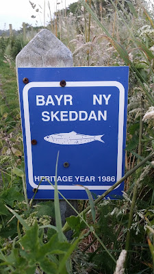
walk the Bayr Ny Skeddan as this also links up with sections of the Millennium
Way and the Raad Ny Foillan. This would allow me to get a flavour of the
different footpaths and if I had time before I left the island, then I would
walk another section of the Raad Ny Foillan as well. For my walk I used Aileen Evans excellent book Isle of Man Coastal Path with The Millennium and Herring Ways, www.Cicerone.co.uk.
We were staying in an
excellent converted barn holiday cottage (www.Ballanchrinkbarncottages.com)
near Castletown and as the joint Millennium Way / Bayr Ny Skeddan section ran
past the end of our farm lane, it made sense to walk the Bayr Ny Skeddan in
reverse from Castletown – Peel. I decided to walk the first small section (1
hour and 10 minutes walking time) from Castletown to Silverdale, one evening
and then continue on to Peel from our holiday cottage the next morning. My wife
therefore dropped me off at Castletown on a sunny but cool and blustery evening
and I began my walk.
Castletown itself is a small
pleasant and picturesque town of narrow streets and a market place, which was
the Isle of Man’s capital until 1869 when Tynwald moved to Douglas. It is
dominated by the fortress of Castle Rushen which probably dates from the late
12th and early 13th centuries. Magnus Olafsson the last
Norse King of Mann and the Isles, died here in 1265 and after a period of
unrest when Scotland and England vied for control of the island it became the
principal fortress of the English controlled Kings and Lords of Mann.
I started my walk by the
narrow harbour where the fishing boats were languishing at low tide and made my
way alongside the Silverburn River, past the town park and out into more open
countryside where rabbits were scattering in the evening light. The nearby
steam railway line runs beside the path and must give excellent close up views
of the steam locomotives during the daytime, but as they don’t run in the
evening, I missed this treat.
Eventually the path crossed
the A7 briefly, which sounds like a very grand and a large busy road, but like
all roads on the Isle of Man was in fact a quiet country road, and I reached
the site of Rushen Abbey at Ballasalla.
Little remains of the abbey,
except the ruined tower, parts of the enclosure wall and a few monastic
buildings, but archaeological investigations were done in recent years and the
site has been made into a tourist attraction with a pleasant garden and café
and the outline of the cloister and abbey church ground plan can be delineated
and a heritage centre has been created.
The abbey was founded in 1134,
with the permission of King Olaf I, by the Savignac monks at Furness, but
quickly came under Cistercian control in 1147 when the two orders merged. The
abbey church of St. Mary was completed in 1257 and the abbey dissolved in the
16th Century.
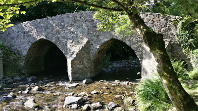
Nearby is a picturesque ford
which you can cross to Ballasalla, but I continued up the Silverburn valley;
now delightfully wooded with deciduous trees and examined the Monk’s Bridge.
Built in 1350 and paved with quartz pebbles, it is a reminder that the monks
developed the land around the abbey, managing and draining it and making it
highly productive.
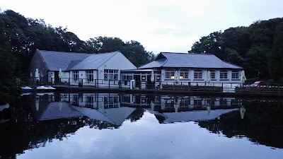
Dusk was falling as I reached
the mill and café at Silverdale Glen and I was eager to get home; all I had to
do was turn right up the A3 for about a kilometre and I would be back at our
holiday cottage in time for supper. Unfortunately, I saw a Manx footpath sign
opposite and I thought the footpath ran parallel to the A3 for a distance
before rejoining it; I had not yet learned that just because you see a Manx
footpath sign, does not mean you should follow it!
So began my self-imposed
adventure; I quickly found myself lost in a footpath that wound it’s way uphill
through shoulder high bracken where startled sheep examined me with a mixture
of alarm and disdain. It got darker and the wind began to get up and I got
damper and damper as I waded through the wet bracken and hoped I would find the
road before it got totally dark.
Eventually I stumbled out onto
a road over a stile; but where was I and which way should I go? I tried walking
one direction and could see Barrule Hill, visible from our cottage and the illuminated
lights of Douglas in the distance, but I seemed to going in the wrong
direction, I tried walking a considerable distance in the other direction but
that seemed to be getting me nowhere either! I had stupidly only brought my
walking book and I had not brought another map or compass as I was only
expecting to do a short walk!
I rang my wife rather
sheepishly and admitted I was totally lost and suggested she should try driving
around the local lanes and see if she could find me! I finally plucked up the
courage or cheek and seeing a cottage in the middle of nowhere still lit,
approached the kitchen window and seeing an elderly gentleman boiling his
kettle and adjusting his radio, knocked the window! He appeared at the door and
I apologised profusely for disturbing him, but explained I was totally lost and
did he know the way back to Ballanchrink?
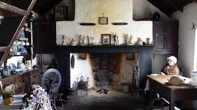
Inviting me in, I was
interested to see that the cottage was extremely old with a very large
traditional Manx open fireplace or Chollaigh
which reached right up to the roof. The inside of the cottage had an
eclectic mix of antiques, tools and a lawnmower. The man’s wife appeared
repeating “my goodness!” when she heard I was lost. I suspected that they were
secretly amused and that the excitement had made their day and had given them something
to tell the neighbours and family!
The kind gentleman offered to
drive me home. On the waydownhill in the car he explained that he was 85 years
old and lived in England, but that his mother was from the Isle of Man and he
had been coming to the island since he was an infant to visit his grandfather
who farmed the surrounding land and was a native Manx speaker. He still shared
the cottage as a holiday home with his two sisters. The area he said, was
called Kerrowkeill and one hundred years ago there were 70 children registered
at the local chapel whereas nowadays, due to emigration few lived there. He
joked that since in the past, superstitions about fairies had been common on
the island, the same as in Ireland, he had thought that “themselves” or the Buggane; a mythical monster that lives
in sea caves, had come for him when I knocked his kitchen window!
 |
| Traditional Chollaigh at Cregneash Folk Village |
Eventually we saw my wife
driving up the road towards us, and drawing alongside and winding down the
window he said to my wife in a tone of one returning an errant child “I think I
have someone belonging to you?”. My wife smiled and rolled her eyes and
thanking him again I returned home chastened for a late supper!
The next morning I set out
again; the weather had improved and was a mixture of cloud and sunshine and the
temperature became practically humid and tropical in some of the sheltered
laneways through which I walked. Turning right out of our farm lane, I walked a
short way along the A3 before turning off left along the Bayr Na Skeddan; we
were leaving the Millennium Way which carried straight on.
This part of the walk gave
fine views of South Barrule Hill and led down muddy lanes after the night’s
rain, past a ramshackle farmstead at Moaney Mooar and uphill in a sunken
embanked lane bespeckled with tiny dew encrusted Forget-Me-Not and blue
Scabious flowers. At the top of the lane, there was a moment when I got lost
again as I missed a sign and wandered across a field of long grass and
wildflowers, but that only gave the chance to see two large hares that I
startled and saw at close range as they raced off.
Back on track and passing
another farm and duck pond at Old Moaney, I climbed steadily and was able to
see expansive views over the south east of the island to Castletown and
Langness. The path continued to climb as I entered the modern Cringle conifer
plantation and due to the strenuous ascent and the humidity caused by the
shelter from the pine trees, I was sweating profusely. I became a magnet for a
vast and harrying squadron of black flies and had to keep going uphill without
resting, desperate to get out of the plantation and back into the breeze which
I hoped would blow away the flies, which were landing on my face and even
getting in my eyes.
The breeze came when I reached
the road junction at Round Table and made my way downhill for some welcome
relief from what had been a fairly constant climb since Moaney Mooar. After a
small climb again, I turned off the road onto pleasant moorland at Glen Rushen;
one of things that impressed me walking on the Isle of Man was how quickly the
landscape can change. I stopped at dry grassy bank for a picnic having been
noisily scolded by Stonechats with their amusing wheezy whistle and comical
grunt and enjoyed examining in detail carnivorous Sundews and a profusion of
Heath Spotted Orchids Dactylorhiza
maculata. I was also delighted to spot a Kestrel returning to it’s nest to
feed it screeching young in a nearby Scots Pine.
Beyond this, the moorland gave
way to another conifer plantation (no flies this time!) and then descended as
Glen Rushen became increasingly steep and wooded. Above on a ridge were the
ruins and spoil heap of Beckwith’s Lead Mine. Mined for Galena, or lead ore,
which also contained a considerable amount of silver, the mine eventually had a
shaft that reached a depth of 1100ft – 500ft below sea level, but it closed in 1910
when it was no longer economic to run.
The valley was now deeply cut
by the River Maye (maye means yellow in Manx) and indeed the riverbed had yellow
rocks linked with the galena vein running through the area. The remains of
slate quarries also lined the side of the river in places and a Peregrine
Falcon was wheeling around above me.
Eventually I entered Glen Maye
village and turning left at the Waterfall Hotel, I was led down into probably
the most beautiful section of the walk – the steeply cut Glen Maye with it’s
cascading waterfall set amidst trees and lush ferns. As I lingered to enjoy the
waterfall, I was surprised to see a large Cormorant sitting impassively like a
large penguin to one side on a rock!
At the bottom of Glen Maye I
joined the Raad Ny Foillan and followed the coastal footpath towards Peel. Fulmars effortlessly rode the updraft from
the cliffs, Sea Campion and Harebells lined the path and I was pleased to spot
two endangered Choughs swooping aerobatically. A middle aged man and his tired
elderly mother came towards me asking how far it was to the next café of pub
and I explained it was a good strenuous 45 minute walk to the Waterfall Hotel
and they decided to turn back to Peel, which I thought very wise as the mother
looked very tired. Overall, however I met few walkers on the Bayr Ny Skeddan.
Eventually we left the Raad Ny
Foillan and descended through well-tended farmland to Glenfaba where I joined
the old Douglas – Peel railway line at Glenfaba Mill – the mill leat of which
still supplies water to the Electric Power Station at Peel which provides power
to the island. And so I reached the end of the Bayr Ny Skeddan at Peel.
 |
| Glenfaba Mill |
Peel is a very pleasant
seaside town with a broad sandy beach and busy little harbour full of yachts
and and fishing boats entered under a swing bridge. In the past, it was famous
for it’s kipper industry; herring would be smoked in factories in the town.
My chief goal however, was to
visit St. Patrick’s Isle – small island now connected to the town by the
harbour seawall, but up until a few hundred years ago it could only be reached
across a sandy spit from the beach. Legend has it that St. Patrick visited the
site, hence it’s name, what archaeological investigations have shown as fact,
however is that it was inhabited in Neolithic times as small amounts of flint
artefacts have been found, dating back to 8,000 B.C. and the remains of a
Bronze Age village (c. 800 B.C.) on the sheltered landward side of the island
has also been excavated.
In the Celtic Christian
period, there was a monastic enclosure and the remains of an Irish style Round
Tower, later converted into a medieval watchtower with battlements and some 10th
Century ruined chapels and churches remain.
The Vikings led by King Magnus
Barefoot saw the defensive advantages of the site and built a wooden fortress in
the 11th Century and St. Patrick’s Isle became the seat of power and
government on the island for the next two hundred years. The wooden fortress
was subsequently rebuilt in local red sandstone in the 14th Century
when the Stanley family were given the Lordship of Mann by Henry IV and as
Earls of Derby they controlled the Isle of Man for the next three centuries.
The most distinctive building
on the whole site however is the ruined cathedral of St. German. The aisle,
transepts and chancel all survive to roof height and although it was finally
abandoned in the 18th Century enough remains to make it still an
impressive building.
Underneath the chancel is the 13th Century crypt or reliquary of St.
German with it’s 14th Century vaulting. One
could imagine pilgrims coming down the steps to visit the relics that must have
been kept there before the Reformation. In the 18th Century the
crypt was used as prison.
And what about St. German with
his strange name; who was he, and what has he got to do with the Isle of Man?
Apparently he was Germanus, Bishop of Auxerre, c. 378 – 448 A.D., who according
to a hagiography written by Constantius of Lyon, travelled to Britain in about
429 A.D. to combat the heresy of Pelagianism which basically said that that
original sin did not taint human nature and therefore people could earn
salvation by their own efforts. St. Germanus was an important influence on the
early Celtic Church in both Cornwall and particularly Wales and at one stage
was supposed to have led a battle against the Picts and Saxons in North Wales.
Legend says he founded the Diocese of Sodor and Man, the seat of which was
transferred in 1980 to the Parish church of St. German in Peel.
Leaving the castle I visited
the beach below the castle walls and scouring the shingle picked up a
distinctive rust coloured scallop shell to give to my friend Ben Jonas who accompanied
me to St. James’s Gate last year and who I have been praying for a lot recently.
He is going to walk the Camino starting on the 20th of September with
his friend Rob Deady and then meet up with us at Belorado when I and a few
friends continue walking the next section to Frómista on the 5th
October. I thought a scallop shell from the site of St. German’s cathedral
would be a nice souvenir and maybe encourage Ben to pray for me on occasion as
he walks on to Santiago.
Before finishing my walk I
took the old railway line past Glenfaba Mill and walked another 5km or so to
St. John’s to finish my walk beside Tynwald Hill, where my wife picked me up in
the car. The distinctive stepped mound, known as Cronk-Y-Keillown in Manx, is said to contain soil from each of the
17 parishes of the Isle of Man. It is 12 feet or 3.7 metres high and contains
four platforms and probably dates from the Norse practice of making public
proclamations on mounds, often called Thing
Walds or Meeting Place of the
Assembly. It was certainly in existence in the 14th Century, and
each year on the 5th July, the laws enacted by Tynwald during the past
year are read out in the presence of Queen Elizabeth or her representatives after
a service in St. John’s Church. It seemed a fittingly ancient and important
place to finish my walk so full of history and interest.
 |
| Tynwald Hill |


No comments:
Post a Comment