After enjoying the Bayr Ny
Skeddan, I took the opportunity to do a little more Camino training and on our
last day on the Isle of Man; I decided to walk a seven mile stretch of the Raad
Ny Foillan from Port St. Mary to Port Erin with my teenage children.
 |
| The Calf of Man Crucifixion slab |
As I explained in my previous
post, the Raad Ny Foillan or Way of the Seagull, is 96 mile coastal footpath
with fabulous scenery that runs around the entire Isle of Man. We hadn’t time
to walk it all, but I had already got a flavour of it between Glen Maye and
Peel and I was eager to see some more and felt the southern tip of the island
would be a good place to experience further examples of it’s spectacular views.
 |
| The "Loch" pulling the 10.27 into Castletown Station |
We were blessed with
exceptional weather – hot sun requiring the first suncream I have actually used
this year, blue skies and sparkling seas. Back home, Ireland was experiencing
the coldest July for 23 years, but the Isle of Man didn’t seem to know this!
 |
| Chapel Bay, Port St. Mary |
The kids and I left our
holiday cottage at 9.00 am and followed the Bayr Ny Skeddan back down to
Castletown via Silverdale. The fourteen year old son, given to a surfeit of
computer games at home was already lagging by the time we reached Castletown
and caught the 10.27 steam train to Port St.Mary, thankfully though, the
daughter was going well! We were amused on the train to note an enthusiastic
steam-mad middle aged dad looking bright eyed as the train clattered along,
whilst his early twenties-something son looked bored and snoozed.
 |
| The harbour, Port St.Mary |
At Port St. Mary we made our
way down to the town centre and followed the broad sweep of Chapel Bay to the
right, towards the harbour. Further along, I was interested and moved to see
the Dunkirk Memorial with an anchor salvaged from TSS Mona’s Isle Queen which
was sunk at Dunkirk, pointing southeast towards the French coast in the centre
on a mosaic compass. Apparently Isle of Man Steam Packet Company ships were
amongst the first to respond to the call to evacuate soldiers from Dunkirk’s
beaches and in the end three unarmed Steam Packet vessels were shelled and
sunk. However, amazingly 1 in 14 soldiers rescued at Dunkirk were done so by
Steam Packet ships – something for which the Isle of Man to be proud of as the sacrifice
of their Merchant Seamen is remembered.
 |
| The Dunkirk Memorial |
 |
| TSS Mona's Isle Queen's anchor pointing towards Dunkirk |
Near the memorial is a large
World War II concrete bombing practice arrow, another reminder of the dark days
of the war and a reminder of the part the Isle of Man played in those difficult
times.
 |
| WW II bombing practice arrow |
We climbed up the side of the
golf course and expansive views opened up behind us across Perwick Bay towards
Port St. Mary, Castletown and Langness. A monument in a stone wall remembered
Ned Madrell, the last native Manx speaker who died in 1972 and used to sit with
his friends to enjoy the view and yarn.
 |
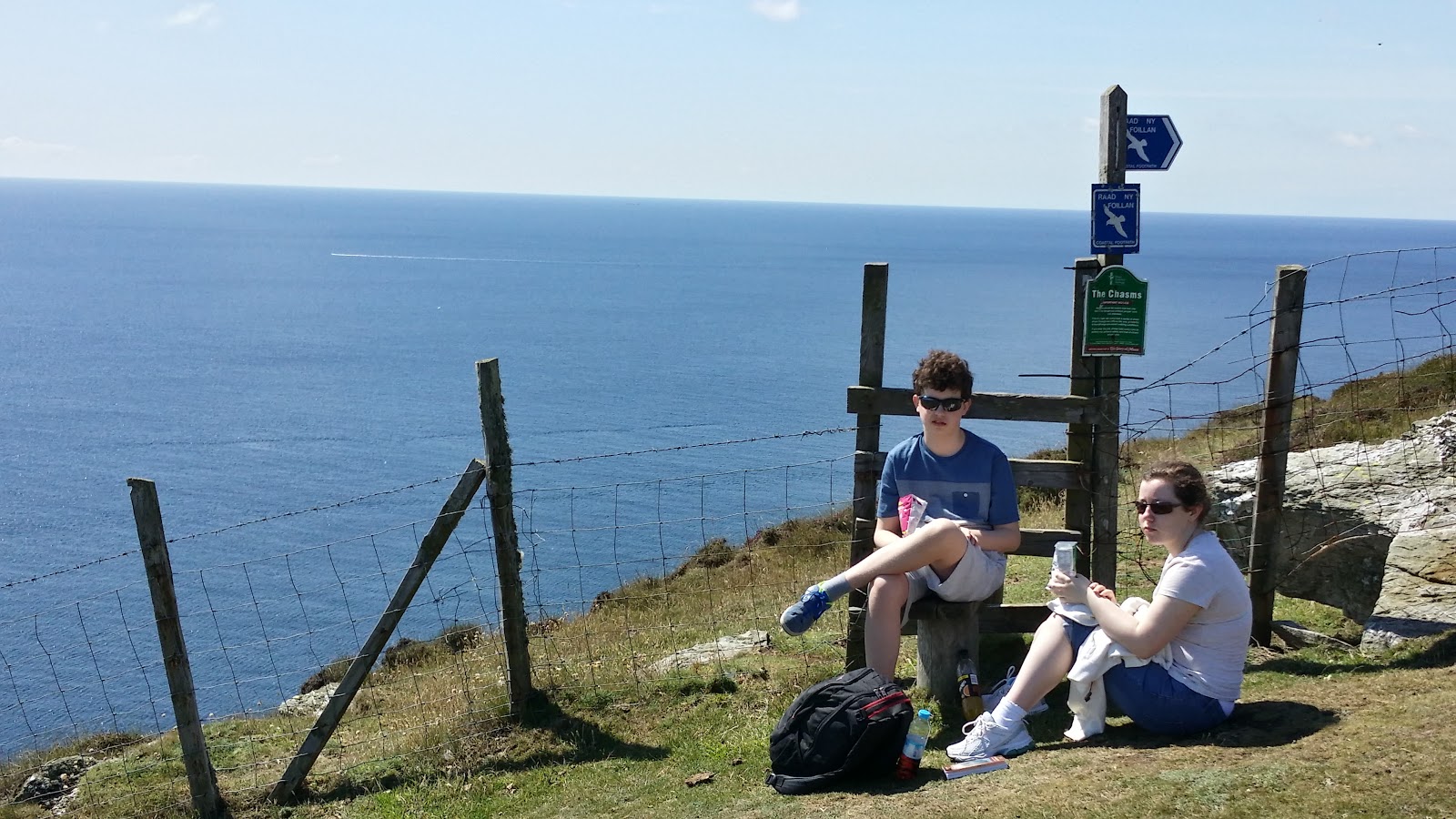
| The son with a Raad Ny Foillan signpost |
We stopped for a snack. The
son was definitely getting tired; the climb had been pretty steep out of Port
St. Mary (for a teenage boy not used to it!) and it was surprisingly hot.
Whilst eating I thought I saw a couple of Choughs. These members of the Crow or
Corvid family are endangered in much of Europe, but seem to be doing well on
the Isle of Man as they like the tightly grazed coastal turf where they can
feed on ants and insect larvae. I am particularly fond of them with their
curved red beaks, red legs, glossy black plumage, cheerful p-koow call and
aerial acrobatics. I used to enjoy seeing them as a teenager on the Causeway
Coast of Co. Antrim, but they are getting very scarce there now.

 |
| Perwick Bay |
As I say, I hoped to see a few
Choughs – maybe a pair or two, I was amazed, therefore when we climbed over a
stile into the area called the Chasms to see literally dozens of them –flocking,
swooping and diving; the greatest concentration of Choughs I have ever seen!
 |
| Snack at the Chasms |
The Chasms is an area of deep
fissures down through the local bedrock and cliffs caused by severe earth
movements. In places the fissures go below sea level and given that some are
covered in heather and vegetation, I kept strictly to the paths and I found looking
down some of them at their depth gave me the creeps! Apparently there have been
some nasty accidents here; I could well imagine. The Choughs however love the
fissures for nesting and a nearby fissured cliff face was alive with them
coming and going to their nests. The Chasms is also a good place to get a
really good view of the Sugarloaf Sea Stack which was still alive with nesting
seabirds such as Guillemots, Razorbills, Kittiwakes, Fulmars, Petrels and Shags.
The noise of the colony was immense, even this late in the Summer and a delight
to watch.
 |
| Great Sugarloaf sea stack |
Walking on round the headland
we could see views back inland to nearby Cregneash Village which has been
turned into a heritage folk village and celebrates Manx culture, language and the
traditions of such bygone crofting settlements that were dependant on fishing
and farming as they eked out a tough existence that finally came to an end in
the first half of the Twentieth Century.
 |
| One of the fissures at the Chasms |
After Spanish Head, which
apparently is named after Spanish sailors rescued from an Armada wreck in 1588,
amazing panoramic views of the Calf of Man came into view. The Calf is a small
island off the south west coast of the Isle of Man, separated from the main island
by a turbulent stretch of waters; Calf Sound and the rocky islet of Kitterland
where seals were wallowing, their plaintive moans carrying up to us high as we
were above them. Also in the background, and to be seen very clearly on such a
fine day, were the Mourne Mountains and the Ards Peninsula in my native Co.
Down and it seemed to me that I could also pick out the Cooley Penisula in Co.
Louth to the south and the Antrim Plateau to the north.
 |
| Cregneash village from Spanish Head |
The Calf of Man is also
interesting because it must have been the site of a Celtic Christian monastic
site. In the 18th Century, when an early Christian chapel was being
demolished, a unique 8th Century Manx slate slab was discovered. It
was carved with a crucifixion scene and shows the still living Christ, with
eyes open and clothed in an ornate robe, flanked by a spear-bearer. The style
of the scene is known from other Celtic representations in manuscripts and
bronzes; indeed the large circular ornament shows that the stone carver was using
a bronze prototype with a central rivet; and the depiction of Christ shows the
artistic links between the Celtic Church in Western Britain and the Church in
the Eastern Mediterranean. The slab was probably an altar front and is now in
the Manx Museum in Douglas where I photographed it earlier in the week.
 |
| Panorama of Calf Sound |
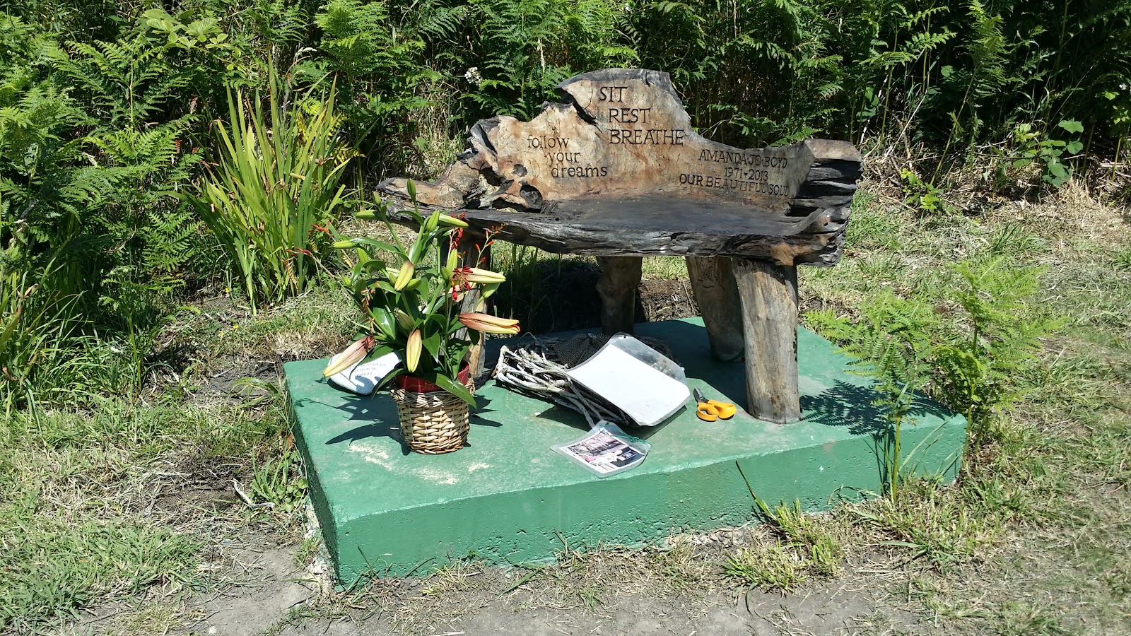
Walking on we came across a
poignant bogwood seat that had an inscription carved into it encouraging
walkers to sit and rest, enjoy the view and dream. Apparently it was a memorial
created by someone called Mark remembering his much loved wife Amanda Jo Boyd
who had died aged only 41. I sat in the chair for a while, as the kids caught
up with me and thought of what it would be like to lose my own wonderful wife
who brings me so much love, joy and happiness and I prayed for Mark.

Nearby is the modern Calf
Sound café which sells good food and has excellent panoramic views of the Sound
from it’s semi-circular glass floor to ceiling windows. My wife Liz, met us
here with a picnic to use up food left over from the previous night’s barbeque
and we fell on it like Gannets! The son decided he had had enough walking, but
he hadn’t done too bad as he had walked about 11km since we left home. We left
him to travel around to Port Erin with his mother in the car and the daughter and
I carried on around the coastal path.
 |
| The Calf from Aldrick |
Further along I was able to
get good views with my binoculars of another Chough feeding in the turf and was
even able to pick up a souvenir discarded Chough feather with its
characteristic square-ish feather end that has been given pride of place in my
study.
 |
| Bradda Head and Port Erin Bay |
A pleasant stroll for about an
hour along the headlands past Aldrick and Bay Fine brought us round to the
lovely little seaside town of Port Erin. Along the way I fell into conversation
with some retired Manx lady hikers who amongst other things, informed me that
they got £180 a week from their Isle of Man state pension; pretty darn good!
The most talkative lady said she was originally from Port Erin but had moved to
the “Metropolis” i.e. Douglas, some years ago!
 |
| Port Erin |
Bradda Head at the entrance to
Port Erin Bay came into view with it’s strangely shaped Milner Tower.
Apparently Mr. Milner was a 19th Century London Safe-Maker who liked
visiting Port Erin and decided to pay for a defensive sea wall in order to
create a safe harbour for the town. When this was finished he threw a party for
everyone to celebrate and the locals were so grateful they built the Milner
Tower from public subscription, in the shape of one of Mr. Milner’s more
successful patented safe keys as a lasting memorial!
Given the beautiful weather,
Port Erin’s beach was packed with families and children bathing and the
daughter and I made our way along the promenade to Davison’s Manx Ice Cream
shop for celebratory cones before being joined by the wife and son.
Approximately 16 km walked; a
very pleasant and satisfactory day’s Camino training!


No comments:
Post a Comment